The city of Recklinghausen manages its eight cemeteries with a digital planning tool. It allows for systematic updating of development planning, improves the organization of inventory data, and facilitates data maintenance for employees.
The cemeteries in the city of Recklinghausen (with around 120,000 inhabitants, located in North Rhine-Westphalia) are managed by the Municipal Service Operations Recklinghausen (KSR). There are a total of around 60,000 burial sites spread across eight cemeteries covering 59 hectares. The shift in burial culture also affects the city of Recklinghausen.
Due to the increasing number of cremation burials, the land consumption on the cemeteries is significantly reduced. Therefore, the management concept needs to be updated considering the resulting open spaces. This is the subject of cemetery development planning, currently spanning all municipal cemeteries.
While the KSR’s existing cemetery plans are digital, as explained by project manager Michel Farin, they are in a drawing program and thus not georeferenced (based on coordinates) and only partly in a consistent scale. In order to create a reliable database, all graves were recorded and transferred to the digital cemetery plan in 2018.
The introduction of the digital cemetery plan aims to achieve the following goals:
- Improvement and acceleration of search processes: The digital cemetery plan aims to better organize inventory data, significantly speeding up the search for burial and deceased data.
- Graphical evaluations: Graphical evaluations based on burial status, type, condition, usage period, and rest period should be easily accessible. Particularly, evaluations based on usage and rest periods are fundamental for the strategic direction of cemetery planning.
- Timeliness and versioning: Linking the digital cemetery plan with the cemetery database ensures its constant updating. Manual reconciliation between the cemetery database and the plan is time-consuming and error-prone and should no longer be done in the future.
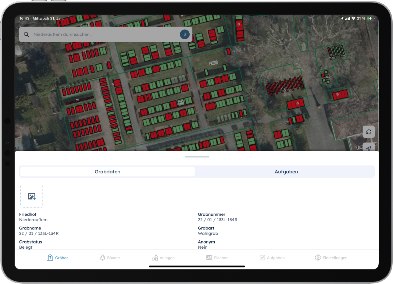
- Publication options: KSR intends to publish the digital cemetery plan in various media and formats. A desktop software with extensive planning and analysis functions is to be procured for planners. Non-technical staff should access the digital cemetery plan via a web application in a simple and user-friendly manner. Additionally, the application should be operated on mobile devices in the medium term. To improve communication with bereaved families, undertakers, stonemasons, and cemetery gardeners, the possibility of publishing the digital cemetery plan on the internet is being considered.
Following goal definition, KSR conducted market research. In the subsequent procurement process, the software “pg_friedhof” (Pbsgeo) was purchased as it meets the desired requirements.
Data collection and construction of the digital cemetery plan were carried out by the Municipal Service Operations within just two months. The rows of graves, paths, and green spaces were surveyed tachymetrically. This involved measuring the position and height of object points in a single operation. Within the rows of graves, the graves were recorded using the planning tool from the aerial image. The combination of these two survey methods resulted in very high accuracies.
Digital Cemetery Plan on the Internet
Michel Farin provides the following interim conclusion: “Employees at the cemeteries can now access the digital cemetery plan at any time. This creates clarity and improves communication within the cemetery administration.”
Next steps include implementing the digital cemetery plan on mobile devices and publishing it on the internet. With the mobile application, employees have the cemetery plan directly available at the cemetery. This is particularly helpful for grave allocations and inspections.
By publishing the cemetery plan on the internet, citizens and bereaved families can inform themselves. This increases the service quality of the cemetery administration while simultaneously reducing administrative effort.
As an additional topic, the pathway areas have now been recorded in the software and categorized according to the following criteria:
- Surface paving
- Categorization (main path, side path)
- Condition of the path (evaluation according to grades)
This is intended to improve the management of cemetery pathways. Furthermore, the updating of the pathway network planning can then be done digitally in direct spatial connection with cemetery development planning.
Farin sees the digital cemetery plan as an ongoing development process. This applies both to the integration of additional topics such as supply and disposal lines and to the technical advancement of the application.
Source: Treffpunkt Kommune, Stefan Schumacher, April 17, 2019
Click here for the original article: Treffpunkt Kommune