The majority of cemetery administrations still work with paper plans. This was also the case for the town of Schorndorf in the Rems-Murr district until 2020. This article describes how the town of Schorndorf moved from a paper plan to a digital cemetery plan.
The cemetery administration of the town of Schorndorf has been using the FIM cemetery database from mps public solutions GmbH in Koblenz for many years. The software is hosted by the state computer center (Komm.One). At that time, the cemetery plans were only available in paper form. This approach was associated with the following technical and organizational disadvantages, among others:
The comparison between the cemetery software and the paper plan was done manually. This procedure was very error-prone, as the daily updates in FIM did not always find their way into the paper plan. In addition, the handwriting in the small boxes often had to be laboriously deciphered.
The paper plans with all the current entries were not available on site at the cemeteries, which meant that the necessary information had to be requested from the office staff.
The paper plan was updated by erasing and pasting over new entries, making the plan increasingly confusing over the years.
The project
The collaboration between the town of Schorndorf and PBSGEO from Cologne began in March 2020. The initial aim of the test phase was to examine the extent to which a sensible solution for cemetery management could be created using the Weiler cemetery as an example. The results of the test phase were very positive. During the course of the project, an interface to Komm.One was also created that meets the high security requirements of the state data center. In August 2020, the project was extended to all of the city’s cemeteries. The data collection was carried out by the cemetery administration itself. A total of 11,397 graves were created and linked to the digital cemetery map. By linking the FIM data, many incorrect (approx. 340) and missing data records (approx. 390) were discovered. These errors were corrected.
Project conclusion
- Thanks to the automated data transfer from FIM to the PBSGEO applications, the previous data transfer errors to the paper plan can be avoided. In addition, updating the cemetery plans is considerably simplified and accelerated.
- By digitizing the cemetery plans, they can now be accessed by all employees of the cemetery administration, even on site with mobile devices at the cemeteries.
- Various graphical evaluations (type of grave, grave status, period of use, resting period, etc.) can be output very easily. These are an important basis for the strategic orientation of cemetery development.
- The digitization project and the associated error corrections have significantly improved data quality.
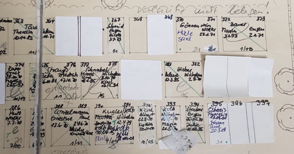
This is what the paper plan looked like: new entries were added by hand, old ones were erased or pasted over.
Online task management
In a further expansion stage, the digital cemetery plan was supplemented with an online task management system. This makes it possible to digitally map and structure the tasks and processes that occur at the cemetery. Access is via a web application or at the cemetery via the PBSGEO cemetery app. Tasks can be recorded with priorities and categories and delegated to the cemetery administration staff. The delegation recipients receive a notification about the pending tasks. Task management considerably simplifies and improves communication between office and field staff. For example, the manual creation and printing of lists in the office and their manual transfer to the field service is no longer necessary. Among other things, the cemetery administration uses it to coordinate notification procedures and grave maintenance. Photos can be captured with mobile devices and attached to the task.
Citizen information system
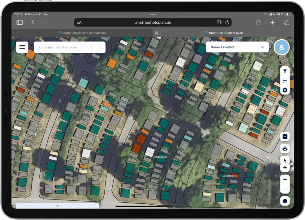
The city of Schorndorf is the first administration in Baden-Württemberg to use PBSGEO’s citizen information system. This has been in use there since January 2022. The map can be accessed at https://schorndorf.friedhofsplan.de. It is clear that the trades working at the cemetery in particular make intensive use of the online information system. A large number of inquiries that previously reached the cemetery administration now go through friedhofsplan.com. The respective cemetery plan can be accessed very easily using mobile devices (smartphones and tablets) via QR codes that are displayed at the cemeteries. Graves can be found quickly and easily by entering the name of the deceased or the grave number.
Online grave reservation
The town of Schorndorf uses PBSGEO’s online grave reservation system to systematize the sale of graves. This means that graves can be sold and the bereaved advised directly at the cemetery. The employees access the digital cemetery map with a tablet and enter the required data directly on the map. When a new grave reservation is entered, the color of the grave changes on the plan so that duplicate reservations can be ruled out.
Since October 2022, Schorndorf has been the first town in Germany to activate an online reservation system for sponsored graves. Interested parties can find out about the number of sponsored graves online and reserve a grave if they are interested.
Ines Hagmann, Head of Urban Greenery at the town of Schorndorf, on the digital cemetery plan and project implementation: “It was a long and labor-intensive journey to the digital plan and the gradual expansion of the application. However, we would do it again at any time because the result is a great benefit for our daily work.”
Source: Friedhofskultur, November 2022