Data collection is an issue that every cemetery administration has to deal with. Due to the multitude of different reasons, technical possibilities and the associated costs, choosing the right recording method is not always trivial.
Everything starts with a central question: What is the data needed for?
Depending on the purpose of the planned capture project, the required capture method must be selected. The following applies: the higher the accuracy of the recording method, the higher the costs.
The following methods are often used for data collection in the cemetery:
- Measuring with the tape measure
- Digitization from orthophotos
- Tachymeter recordings
- Laser scanning
- Drone surveying
- Drone surveying in combination with tachymeter surveying
- Digitization from orthophotos in combination with tachymeter measurement
The aforementioned recording methods are compared in Figure 1 in terms of costs and accuracies. Methods with high acquisition costs and low accuracies (red quadrant) should be neglected. Methods that, on the one hand, provide high levels of accuracy and, on the other hand, are associated with low costs (green quadrant) would be desirable. Generally speaking, such methods do not exist. Nevertheless, taking into account the local conditions and the required accuracies, a method can be chosen that approximates the green quadrant.
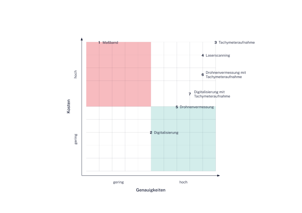
As shown in Figure 1, Method 1: Measuring with the tape measure is in the red quadrant and can therefore be ignored in further consideration. The tape measure is a wonderfully simple measuring instrument for determining individual tension dimensions. It is extremely unsuitable for complete data collection in the cemetery.
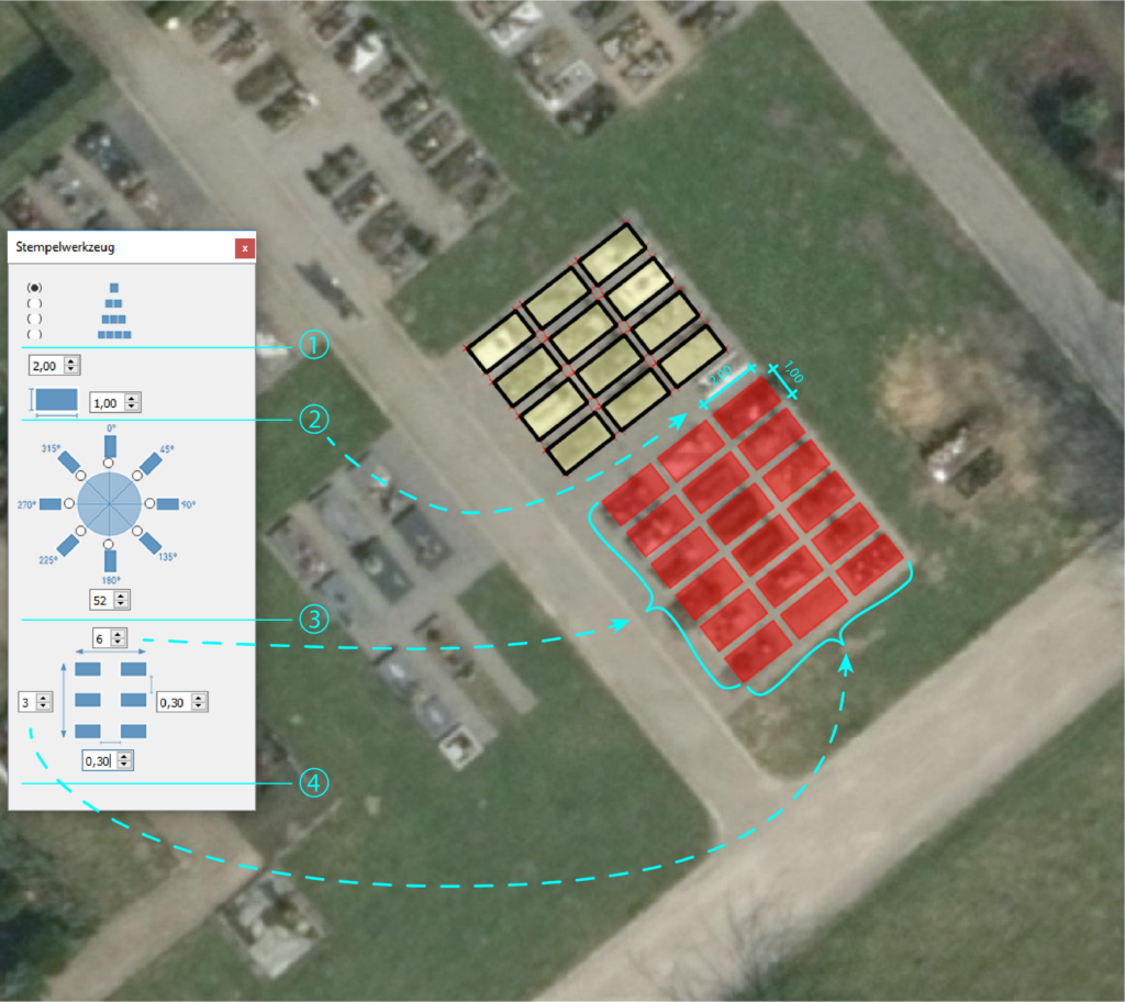
Digitization from orthophotos is the most cost-effective method of collecting data in the cemetery. Orthophotos are a distortion-free and true-to-scale image of the earth’s surface and are available from relatively high to medium ground resolutions (approx. 10-30 cm). During digitalization, graves, paths and green areas are recorded from the aerial photograph without terrain heights and drawn into a GIS or CAD plan. For the cemetery, there are geometry tools (See Figure 2) that can significantly speed up data collection from aerial images. Method 2 is very suitable for creating occupancy plans and preparing area balances. Dense trees make digitization from aerial photos significantly more difficult. It is then possible to fit graves into the plan by constructing them or, in order to achieve greater accuracy, to record the shading areas using alternative measuring methods.
Method 3, the tachymeter recording, is used very frequently in civil engineering measures (road construction, canal construction, etc.) or in sovereign tasks of the ÖBVI (border survey, border display, etc.) due to the high recording accuracy. Each recording point is visited locally and measured. The acquisition costs are very high, especially with a large number of measuring points. Dense trees make method 3 difficult. However, exact measurement results can still be achieved. The tachymeter recording is particularly suitable for punctual and linear recordings
Construction work in the cemetery, for example the construction of a staircase or the replanning of cemetery paths. The entire recording of a small cemetery using a tachymeter also makes sense if there is a low point density.
In method 4, laser scanning, the environment is scanned using a rotating laser beam, creating a digital, three-dimensional image of reality, also known as a point cloud. High levels of accuracy can also be achieved with this method. Laser scanning is particularly suitable for surveys that require a high point density, for example in urban road construction. In the cemetery, method 4 is particularly important when collecting data for new cemetery concepts, as this requires a complete recording of the planning or observation area. All cemetery areas and the existing infrastructure are measured in the correct position and height.
During drone surveying (method 5), the detection area is flown over. The drone determines its own position using high-precision GNSS sensors while taking an aerial photo. This method is particularly used when recording large areas, for example in opencast mining. Drone surveying reaches its limits when there are dense trees and ground cover. In these areas, consistent area recording cannot be carried out. Similar to Method 3, the drone shot is very close to the green quadrant. Method 5 is also very suitable as a basis for new cemetery concepts, as large areas with a high point density can be recorded very quickly. Drone measurements are often used as a basis for occupancy plans and area balances. Particularly when the orthophotos from the state surveying offices are available at low ground resolutions.
It is also possible to combine recording methods (methods 6 and 7) and thereby compensate for the disadvantages of one recording method with another.
As shown, there are a variety of relevant procedures and each cemetery is unique. Therefore, at the beginning of every data collection project, the method should be chosen that is closest to the green quadrant or, desirably, in the middle of it.
Source: Friedhofskultur, November 2020